Search Term Record
Metadata
Name |
Aerial Photos |
Related Records
-
2005.16.10 - Print, Photographic Digital
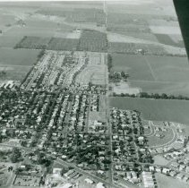
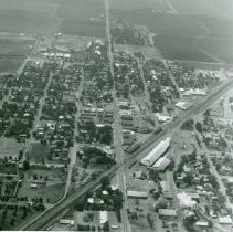
Aerial photo of Dixon, California 1974. Looking east from Lincoln and West A Streets to about Adams Street. Dixon Medical Building and the Tamplen residence on the west side of Lincoln Street. C. A. Jacobs Intermediate School on the east side of Lincoln and Silveyville School on North Almond Street in view. Almond Tree subdivision has not yet been built. North LIncoln Street ended at the school property line. Harold Axelson has the original...
Record Type: Photo
-
2005.16.19 - Print, Photographic Digital
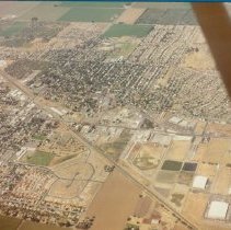
Aerial photo of Dixon, California 1980. Looking southwest from Doyle Lane. Railroad tracks bisect town. Jumbo/Hometown Market had just been constructed at North Adams and North First Street. Mace Meat/Armour Meat Company had not yet been demolished. Harold Axelson has original photo.
Record Type: Photo
-
2005.16.2 - Print, Photographic Digital
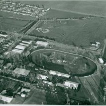
Aerial photo of Dixon, California May Fair Grounds 1975. Little League ballpark in the upper part of the photo. Collier Manor subdivision (7th and 8th Streets) in the upper left. Harold Axelson has the original.
Record Type: Photo
-
2005.16.5 - Print, Photographic Digital
Aerial photo of Dixon, California 1970's. Looking south on First Street (Highway 113) from Dixon Dryer (Cargill) railroad tracks area. Harold Axelson has the original photo.
Record Type: Photo
-
2005.16.6 - Print, Photographic Digital
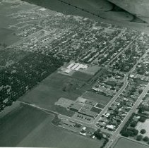
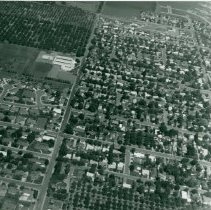
Aerial Photo of Dixon, California 1970's. Looking north on Almond Street. Sievers and Marvin Way are cul-de-sacs in lower left corner. West A Street is the main east/ west street. Silveyville School in upper left corner. Almond Tree subdivision was built in the almond orchard north of the school in 1975. Harold Axelson has the original photo.
Record Type: Photo
-
2005.16.7 - Print, Photographic Digital
Aerial photo of Dixon, California c. 1977 looking west on H Street from North Adams to Interstate 80. Almond orchard in the upper middle of photo west of new Almond Tree subdivision is on Pitt School Road. Pitt School was then a one lane pot-holed road! Watson family home and barns are in tree grove on H Street, west of Almond Street. That area is now Northwest Park. Harold Axelson has the original photo.
Record Type: Photo